Climate modeling and weather prediction could take a giant step forward in the next decade with an instrument concept developed at the Jet Propulsion Laboratory. The Geostationary Synthetic Thinned Aperture Radiometer, or GeoSTAR, is a microwave atmospheric sounder based on aperture synthesis which fulfills a long-held wish among the atmospheric science community: to monitor atmospheric processes under all weather conditions from geostationary orbit.
Current numerical weather prediction models are widely recognized as having an inadequate representation of the processes of cloud formation, evolution and precipitation. They rely on simplistic parameterization schemes and an incomplete understanding of underlying cloud microphysics to represent the most rapidly changing weather phenomena. Frustratingly, the majority of satellite sensors operate at visible and infrared wavelengths and do not penetrate clouds nor observe the internal microphysics of clouds and storms. Polar-orbiting satellites provide only brief snapshots twice a day when a satellite passes over a swath of the planet.
The solution to these problems would be to place a microwave sounder instrument, which can monitor water vapor and temperatures below the cloud tops, into geostationary orbit, where it can continuously stare at an entire hemisphere. Until recently, technology limitations prevented serious consideration of such an undertaking. Operating at approximately 50 times higher altitude than instruments in low-Earth orbit, or LEO, a geostationary microwave sounder requires an aperture of correspondingly larger diameter. Mechanical, structural and manufacturing concerns make parabolic dish antennas of the required size unrealistic in the near future.
The GeoSTAR concept overcomes these difficulties by synthesizing a large aperture. The instrument borrows the approach employed for many years by radio astronomers, as in the Very Large Array operated by the National Radio Astronomy Observatory in New Mexico.
The PATH Ahead
In a recent decadal survey of critical, future NASA and NOAA Earth science missions, the National Research Council recommended that NASA undertake the Precipitation and All-weather Temperature and Humidity, or PATH, mission. PATH would place a microwave atmospheric sounder into geostationary orbit, operating in the same temperature and water vapor bands used by the low-earth-orbiting Advanced Microwave Sounding Units, or AMSU. The NRC identified a microwave array spectrometer, like GeoSTAR, as the recommended instrument payload for PATH.
The GeoSTAR Approach
GeoSTAR is a spatial interferometer that essentially measures the upwelling radiation emitted by the atmosphere in the spatial Fourier domain. This is accomplished by deploying a large number of individual microwave receivers arranged in a sparsely filled two-dimensional array. In the baseline configuration there are three linear arrays arranged in a “Y” shape; the effective aperture is defined by the circle that circumscribes the “Y.” In this way it is possible to form the large effective aperture required for geostationary satellites and still achieve adequate spatial resolution.
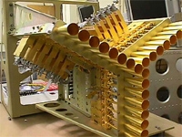
A small proof-of-concept prototype GeoSTAR instrument was completed in 2006 under the NASA Instrument Incubator Program. Led by atmosphere scientist Bjorn Lambrigtsen, JPL’s Microwave Systems Technology Group developed and tested the prototype in partnership with the NASA Goddard Space Flight Center and the University of Michigan. The work was closely coordinated with the NOAA NESDIS Office of System Development to ensure that the GeoSTAR design will meet the needs and measurement requirements of NOAA as well.
The PATH measurements require penetration well into clouds, and that requires temperature sounding in the 50-70 GHz oxygen absorption band and water vapor sounding at the 183 GHz water vapor line. The baseline GeoSTAR design consists of a dual collinear array, one with about 300 receivers in the 50-GHz band and one with nearly 600 receivers in the 183-GHz band. Each “arm” of the 50-GHz array is approximately 2 meters long. That results in a spatial resolution of 50 km for temperature sounding and 25 km for water vapor sounding – comparable to AMSU systems in LEO. Future versions are envisioned to have significantly higher spatial resolution, which can be achieved by adding receivers and thus extending the lengths of the array arms.
Significant Advancements
With a GeoSTAR payload onboard, PATH would provide a number of measurements that are crucial for monitoring and predicting hurricanes and severe storms everywhere and all the time, even in the presence of clouds. These parameters will be derived from a continuous stream of two-dimensional radiometric “synoptic snapshots” covering Earth’s entire visible disc.
With these capabilities, GeoSTAR would be a prime hurricane sensor, in addition to providing the basic sounding functions required by operational agencies for regional weather prediction, and would also provide key observations needed for studies related to the hydrologic cycle. In particular, with GeoSTAR the diurnal cycle can be fully resolved, and atmospheric processes related to cloud dynamics and convection can be studied without the diurnal temporal sampling biases that are prevalent with polar-orbiting sun-synchronous satellite sensors.
An intriguing possibility for implementing the PATH mission in the near term is to fly it as an “instrument of opportunity” on one of the first geostationary satellites in the GOES-R series now being developed by NOAA. This approach would simultaneously implement the PATH decadal survey mission for NASA and provide an advanced geostationary sounder for NOAA at greatly reduced overall mission cost. The launch of the first GOES-R satellite is slated for the end of 2014, and the second satellite is planned for two years later.
Continuing technology development and application studies are under way, funded by NASA and NOAA, which should enhance the system’s performance and retire technology risk. The GeoSTAR team anticipates that a space mission could be implemented in the 2014-2016 time frame – making a PATH/GOES “rideshare” mission feasible.
References: * B. Lambrigtsen, S. Brown, T. Gaier, P. Kangaslahti, A. Tanner. "A baseline for the Decadal-Survey PATH mission." IEEE Proc. IGARSS 2008, vol. 3, pp. 338-341, 2008. * A. Tanner, W. Wilson, B. Lambrigtsen, et al. "Initial results of the Geostationary Synthetic Thinned Array Radiometer (GeoSTAR) demonstrator instrument." IEEE Trans. Geosci. Remote Sens., vol. 45, no. 7, pp.1947-1957, 2007.
Contact Information
Bjorn Lambrigtsen - JPL AIRS Atmospheric Science
E-Mail – Bjorn.Lambrigtsen@jpl.nasa.gov
Phone - 818.354.8932