In atmospheric science, a radio occultation (RO) is an active remote sensing method whereby a receiver, usually on a satellite in low-Earth orbit, tracks the radio signal from a Global Navigation Satellite System (GNSS) satellite, such as the GPS system, as the GNSS satellite rises or sets behind the Earth. As the GNSS signal traverses the atmosphere, it is bent due to variation in the index of refraction of the atmosphere. This bending can be precisely measured and used to extract the vertical structure of thermodynamic properties like temperature and water vapor. Though the technique has been around for decades, a team led by Estel Cardellach at the Institute for Space Science (ICE-CSIC /IEEC) in Barcelona, Spain, have recently launched a new Radio Occultation and Heavy Precipitation (ROHP) experiment on the PAZ spacecraft, which is owned and operated by HISDESAT. Designed by NASA’s Jet Propulsion Laboratory in Pasadena, California, this experiment’s instrument was transferred to industry in 2007, where Broad Reach Engineering Company in Golden, Colorado (now Moog, Inc.) modified, built, and delivered it to ICE-CSIC for installation and launch. ROHP is equipped with the first space-based instrument with a dual polarization GNSS receiver, and has opened up new science possibilities for characterizing the moisture structure associated with convective clouds and associated heavy precipitation.
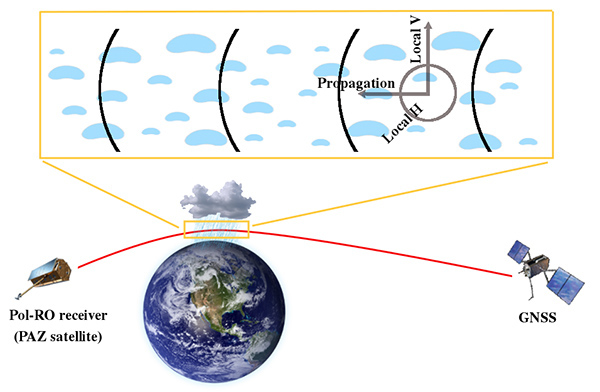
The receivers aboard current GNSS-RO missions, such as COSMIC, use an antenna that is designed to receive GNSS transmissions at a single polarization state. As the GNSS signal propagates through precipitation in the atmosphere, a smaller, secondary, cross-polarized signal is induced because precipitation-sized hydrometeors are aspherically shaped (i.e., flattened by aerodynamic forces). The JPL-Spain team considered updating the antenna so that it could measure the GNSS signal at both polarization states. “This idea was inspired by previous works on the Deep Space Network and GOES telecommunication links showing that hydrometeors affected the amplitude of polarized radio signals at GNSS wavelengths,” recalled Manuel de la Torre Juarez, a JPL scientist involved in the early formulation of the concept.
The team theorized that effects similar to what was found in the previous work could actually be observed in the GNSS phase measurements due to their high level of precision. “The GNSS signals are tracked simultaneously with two linear, orthogonal polarized antennas,” said Chi Ao, a JPL research technologist specializing in GNSS-RO, “This allows us to infer the differential phase shift between the horizontal and vertical components of GNSS signals, which is linked to the presence and intensity of precipitation along the ray path.” With a relatively simple change in instrumentation, the team decided to test the theory that it would be possible to detect heavy precipitation conditions using GNSS-RO, thus providing a new set of observations to jointly characterize water vapor and precipitation under extreme weather conditions.
Funded by NASA’s Research Opportunities in Earth and Space Science (ROSES) program, the JPL team was able to work closely with the ICE-CSIC/IEEE team to model and evaluate the capabilities of the dual polarization RO technique. Followed by a mountain top field test, the ROHP receiver was deployed as a secondary payload onboard HISDESAT's PAZ spacecraft, launched in February 2018 from Vandenberg Air Force Base in California.
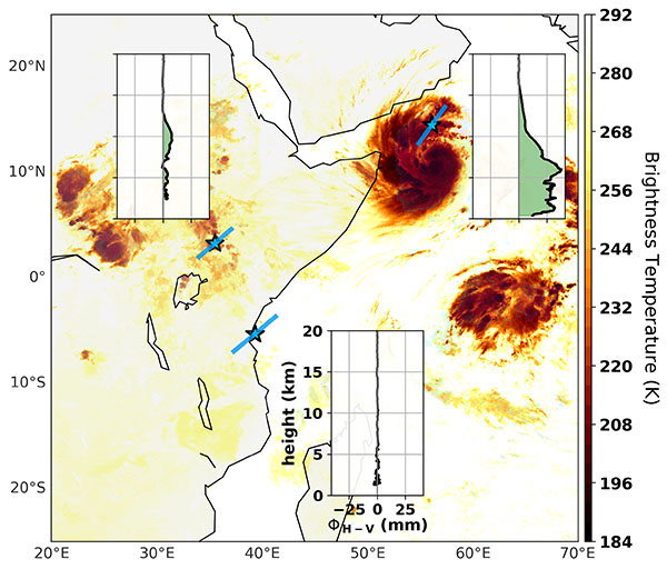
The team’s theory turned out to be correct – ROHP was the first in-flight validation of a space-based dual polarization radio occultation experiment. “Interpretation of the first six months of ROHP data clearly indicates that the new receiver on PAZ is able to distinguish water vapor profiles captured during heavy precipitation from those captured under non-precipitating conditions,” explained Ramon Padulles, a NASA Postdoctoral fellow at JPL who carried out the data analysis. This breakthrough means that the updated receiver on PAZ can measure how thermodynamic properties of storms (like temperature and water vapor) are structured under heavy precipitation conditions, expanding the capability of the RO technique to provide a more complete picture of convective events such as hurricanes.
JPL collaborated with CSIC and University Corporation for Atmospheric Research (UCAR) in Boulder, CO to process the data. The ROHP measurements were validated with data from NASA’s Global Precipitation Measurement (GPM) satellite, using GPM’s Dual Frequency Precipitation Radar (DPR) and Integrated Multi-satellite Retrievals for GPM (IMERG) precipitation products. The JPL team was surprised that the signal was sensitive to not only the near-surface liquid precipitation, but also to upper level ice, and future work could include characterizing the full vertical cloud structure.
The observations collected from the PAZ-ROHP receiver can be relevant for modeling studies on deep convection. They can help assess the capabilities of current climate models to improve their representation of convective precipitation, and perhaps be assimilated into weather forecast models to help improve the forecast of extreme weather events. This low-cost change to the typical GNSS receiver demonstrated with PAZ-ROHP can be adapted on future instruments (even CubeSats), enabling researchers to gather new measurements.