Atmospheric dynamics and composition encompass the physical and chemical processes in the atmosphere related to weather, air quality, and climate. The interplay between atmospheric dynamics and composition can be seen, for example, in the rapid uplift of pollution from the Earth’s surface in convective storms and subsequent long-range transport by winds aloft and in the alteration of clouds and convection by aerosol particles. Four JPL science groups are engaged in research related to atmospheric dynamics and composition. Their research covers a wide range of topics and supports spaceborne observations through theoretical studies, data analysis, modeling, and laboratory and field experiments. Our scientists are also engaged in developing new observational techniques to fill gaps in the current system, often building simulation systems that make it possible to explore the scientific and societal value of new measurements.
Current Challenges
Weather
- How do small-scale weather processes interact with the large-scale environment?
- What controls the intensity, distribution, and likelihood of convective storms?
- How can we use satellites to improve modeling and prediction of weather events?
Air quality and atmospheric chemistry
- To what extent are anthropogenic emissions and natural processes each driving changes in tropospheric composition and air quality?
- Is the stratospheric ozone layer changing as expected?
- What role do dynamical processes play in establishing the composition of the atmosphere, and what drives their variability?
- How good are models of chemical reactions and the rate at which they occur?
- What are the human health impacts of different types of air pollution?
Climate
- How well do climate models agree with observations, and how can we use satellite observations to improve climate models?
- What are the radiative impacts and feedbacks associated with observed changes in tropospheric and stratospheric composition, including aerosols and clouds?
- What are the relationships among aerosol, cloud, and precipitation and how do these relationships impact Earth’s radiative budget, climate feedbacks, and the water and energy cycles?
Atmospheric measurement techniques
- How well do we understand the spectral signatures of gases in the atmosphere?
- How good are satellite measurements? What surface-based, airborne, and balloon-borne field measurements are needed to validate and extend the impact of spaceborne observations?
- What instrumentation will be used in future atmospheric dynamics and composition missions? How will different instruments be built, tested, and proven?
To meet these challenges, JPL researchers are focused on spaceborne remote sensing, collecting suborbital measurements, conducting laboratory studies, and modeling activities.
Spaceborne Remote Sensing of the Atmosphere
Scientists at JPL use satellite observations to detect and attribute changes in weather and atmospheric composition, to reduce uncertainties in models of the Earth System and their projections of the future evolution of climate, and to develop new analysis techniques and observing strategies that can enable the use of satellite observations in applications such as severe storms and air quality.
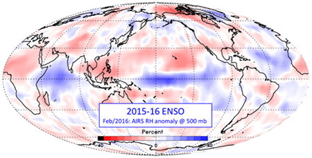
The Atmospheric Infrared Sounder (AIRS) was launched on the Aura satellite in 2002 and is still working well. It was the first hyperspectral sounder and measures infrared light emitted by the Earth in 2378 channels, with four additional channels measuring visible light. It produces 2.9 million spectra and 324,000 soundings of atmospheric temperature, humidity, and cloud properties globally every day. Spectra (radiances) are assimilated into numerical weather prediction systems worldwide, resulting in significant improvements in weather forecast accuracy. The retrieved geophysical measurements are widely used in atmospheric process studies and climate research. Microwave sounders, the Advanced Microwave Sounding Unit (AMSU) and its variants, and the Advanced Technology Microwave Sounder (ATMS), are also important, with JPL being responsible for NASA’s microwave data products and the algorithms used to generate them. New algorithms are being developed, both to improve the retrievals from AIRS and AMSU/ATMS and to merge data from additional sensors, such as the Cross-track Infrared Sounder (CrIS) now flying on NOAA satellites.
The Tropospheric Emission Spectrometer (TES) on the EOS-Aura satellite operated from 2004 through early 2018. TES is a Fourier transform spectrometer designed to make global measurements of tropospheric ozone and its chemical precursors, including carbon monoxide, ammonia, methanol, formic acid, and peroxyacetyl nitrate. Because TES observes the infrared portion of the electromagnetic spectrum and has particularly high spectral resolution, it also measures the radiative impact of these constituents and captures the signatures of a broad array of other atmospheric gases that contribute to studies of the water, nitrogen, and carbon cycles.
JPL scientists are producing high-quality records of tropospheric composition from other infrared sounders such as CrIS and AIRS and are combining those measurements with measurements from additional instruments, such as the Ozone Monitoring Instrument (OMI), that utilize the near-infrared and ultraviolet portions of the spectrum. This work is leading to the creation of long-term Earth Science Data Records of tropospheric ozone and other trace gases with vertical resolution superior to that of measurements from any individual instrument. These records allow us to address key questions regarding the processes that drive changes in tropospheric composition, and the impact of those changes on air quality and climate. Concurrently, efforts are in progress to develop the next generation of instruments and algorithms for remote sensing of the troposphere.
The Orbiting Carbon Observatory missions (OCO-2 and OCO-3) are collecting measurements that continue to provide a clearer, more complete picture of global carbon dioxide and solar induced fluorescence (SIF), providing new opportunities for understanding the processes that regulate atmospheric carbon dioxide, its role in the global carbon cycle and the interaction between carbon and climate. OCO-2, launched in July 2014 in a sun-synchronous orbit, samples in a 16-day repeat cycle with a 1:30PM equator crossing time. OCO-3, flying on the International Space Station since May 2019, samples different times of day and offers a new “snapshot" mode that is, for the first time, capable of mapping localized differences in carbon dioxide from space. In combination with other satellite trace gas measurements, the OCO-3 snapshot area maps also provide opportunities for examination of carbon/air quality synergies.
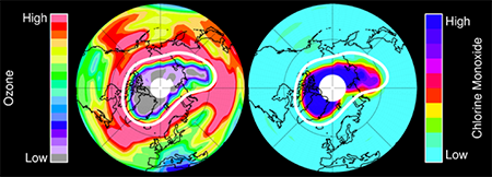
The Microwave Limb Sounder (MLS) instruments measure naturally-occurring microwave thermal emission from the limb (edge) of Earth's atmosphere to remotely sense vertical profiles of a large suite of atmospheric trace gases from the upper troposphere through the stratosphere and into the mesosphere, as well as temperature and cloud ice water content. The first MLS satellite experiment was on the Upper Atmosphere Research Satellite (UARS), launched in 1991 to assess the threat that chlorofluorocarbons and other halogenated gases posed to stratospheric ozone. The second, EOS MLS, is on the Aura satellite. The MLS instruments have provided invaluable information on the depletion and recovery of the ozone layer, the radiative impacts and feedbacks of changes in stratospheric composition, humidity, and circulation, and the transport and spread of pollution in the upper troposphere. Dramatic advances in microwave technology, largely driven by the communications industry, enable significant cost reductions for future microwave instruments. Technology-development efforts are underway to mature potential future MLS-like instruments that can add to the observation record.
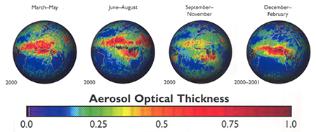
The Multi-angle Imaging SpectroRadiometer (MISR) instrument onboard the Terra spacecraft collects multi-angle images at visible and near-infrared wavelengths, enabling it to measure the heights of clouds and smoke, dust, and volcanic ash plumes, retrieve height-resolved tropospheric wind vectors, and determine the abundance and types of airborne particles known as aerosols. MISR’s nine cameras, observing the Earth at nine different angles of view, have been collecting global data since 2000. New observational capabilities, including extended spectral range and accurate polarimetric measurements have been developed that provide additional details about the sizes and shapes of these airborne particles, which is important for addressing challenges related to their climatic and environmental impacts. These measurement capabilities are being incorporated into the Multiangle Imager for Aerosols (MAIA) satellite. The MAIA investigation was funded through the NASA Earth Venture program specifically to investigate the human health impacts of aerosol pollution for a set of target cities around the world, and passed its Critical Design Review in June 2019. Launch is planned for mid-2022.
CloudSat provides observations necessary to advance our understanding of the abundance, distribution, structure, and radiative properties of clouds. Since 2006, CloudSat has flown the first satellite-based millimeter-wavelength cloud radar, which is more than 1000 times more sensitive than existing weather radars. Unlike ground-based weather radars that use centimeter wavelengths to detect raindrop-sized particles, CloudSat's radar allows us to detect the much smaller particles of liquid water and ice that constitute the large cloud masses that make our weather.
Suborbital Atmospheric Measurements
Researchers at JPL perform many suborbital remote and in situ measurements of the atmosphere and routinely support field campaigns. These measurements augment satellite remote sensing and provide additional datasets needed to answer the questions described above.
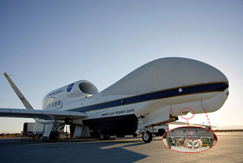
The High Altitude MMIC Sounding Radiometer (HAMSR) is an aircraft microwave sounder that was developed at JPL in 2001 and has participated in a number of field campaigns since then to study hurricanes and tropical meteorology, atmospheric rivers, and winter storms. HAMSR has much higher spatial resolution than satellite sounders and provides a closeup view of both the interior of storms and their environment. It has flown on NASA’s high-altitude ER-2 (piloted) and Global Hawk (unpiloted) aircraft as well as the larger DC-8. HAMSR data are used in research to help us improve our understanding of dynamic storm processes. When it flies on the Global Hawk, the data are immediately transmitted to the ground via satellite and can then be used in near-real-time forecast applications, for example by analysts at the National Hurricane Center.
As precursors to the MAIA satellite instrument, airborne instruments that provide multispectral and multi-angle observations and that also measure the polarization of light scattered by aerosols and clouds have been developed. The principal example is the Airborne Multiangle Spectropolarimetric Imager (AirMSPI), which has been flying aboard NASA’s ER-2 high-altitude research aircraft since 2010 and most recently participated in the FIREX-AQ field campaign in summer 2019. AirMSPI observes in the ultraviolet, visible, and near-infrared regions of the spectrum. A second generation instrument, AirMSPI-2, extends the spectral range into the shortwave infrared. Work under the Airborne Instrument Technology Transition program is underway to make AirMSPI-2 ready for participation in scientific field campaigns.
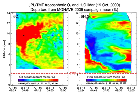
Balloon-borne remote sensing measurements of upper atmospheric composition from the Mark IV interferometer and the Submillimeterwave Limb Sounder (SLS) provide a long-term record of stratospheric composition that has served as validation for a host of space-based instruments, including UARS MLS and EOS MLS. These vertically-resolved measurements are supplemented by more frequent ground-based measurements of the entire atmospheric column from Mark IV as well as the Fourier Transform Ultraviolet Spectrometer (FTUVS) instrument at the JPL Table Mountain Facility (TMF). Ground-based observations are an accurate method of ascertaining whether the composition of the Earth's atmosphere is changing. Ground-based measurements from Lidar (LIght Detection and Ranging), which is an active remote sensing technique that achieves high vertical resolution using the properties of light scattering by atmospheric molecules and particles, also provide long-term time series of trace gases and temperature and validation datasets for satellite and airborne measurements. The TMF Lidar Group measures high-resolution profiles of stratospheric ozone and aerosols (15-50 km), tropospheric ozone (3-25 km), temperature (15-90 km), and water vapor (3-20 km). The group’s four lidars deployed at TMF and Mauna Loa Observatory, HI (MLO) have been operating for three decades, and contribute to the long-term records of the international Network for the Detection of Atmospheric Composition Change (NDACC). The tropospheric ozone lidar also provides measurements for the new US-based Tropospheric Ozone Lidar Network (TOLNet), and the water vapor Raman Lidar contributes to the new World Meteorological Organization climate-monitoring network GRUAN (GCOS Reference Upper Air Network).
As part of the JPL-TMF Lidar Group observation Program, three different types of balloon-borne in situ instruments are launched from TMF. Vaisala RS92 Pressure-Temperature-Humidity (PTU) radiosondes have been systematically launched since 2005 in support of the water vapor Raman lidar calibration, providing hundreds of temperature and humidity profiles in the lower and middle troposphere. Electro-Chemical Cell (ECC) ozonesondes are also regularly launched for the validation of satellite and airborne measurements and for profile comparison with the lidar measurements. Frost-Point hygrometers (CFH and NOAA-FPH) are also launched during campaigns to validate the lidar measurements in the upper troposphere/lower stratosphere. JPL also has several instruments that perform in situ measurements of atmospheric CO2, H2O, CO, CH4 using Tunable Diode Laser Spectrometers from balloons and aircraft such as Global Hawk, ER-2, WB-47 and small UAVs.
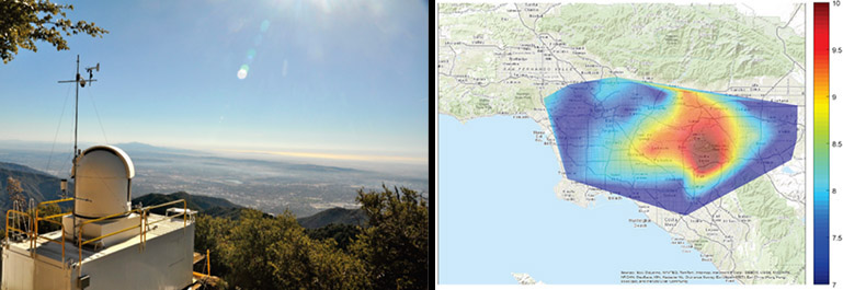
The California Laboratory for Atmospheric Remote Sensing (CLARS) is an observing facility for the measurement of greenhouse gases and pollutant emissions from sources in the South Coast Air Basin. The current instruments at CLARS includes both point and imaging Fourier transform spectrometers (FTS) built by JPL. These instruments operate autonomously, measuring dry air mixing ratios of carbon dioxide (CO2), methane (CH4), carbon monoxide (CO), water vapor (H2O, HDO), nitrous oxide (N2O), and aerosols. The CLARS facility also hosts atmospheric monitoring equipment that is part of California Air Resources Board’s permanent air quality network in California.
Laboratory Studies
Laboratory activities involve the use of state-of-the-art experimental techniques to measure kinetic, photochemical and spectroscopic parameters related to elementary atmospheric processes. Rate coefficients, cross sections and quantum yields are measured using methods such as laser photolysis, discharge-flow and steady-state photolysis combined with high-sensitivity detection methods such as molecular beam mass spectrometry, long-path UV-visible-NIR absorption, diode laser wavelength modulation spectroscopy and laser-induced fluorescence.
These measurements fill in the gaps in our understanding of air quality and atmospheric chemistry. Particular attention is given to studying processes that play important roles in polar ozone depletion, long-term trends in stratospheric ozone at mid-latitudes, the oxidizing potential of the troposphere, and the formation of oxidants in urban and regional environments.
Quantitative spectroscopy is another key focus of the laboratory studies program. JPL’s Molecular Spectroscopy Team uses observations of molecular signatures from the microwave through the ultraviolet spectral regions to measure spectroscopic parameters of atmospheric molecules with extremely high precision and accuracy. NASA remote sensing instruments require these parameters for the measurement of atmospheric composition and structure, important for Earth and planetary sciences, astrobiology, and astrophysics investigations.
Modeling
In this area, computer models of atmospheric processes are developed and used to interpret data from satellite and field measurements, as prognostic tools to help understand long-term changes in climate and composition, and to diagnose elementary processes in atmospheric transport and chemistry. Modeling supports research related to all of the key challenges in atmospheric dynamics and composition, including the development of new measurement systems.
For tropospheric studies, researchers use three-dimensional chemistry transport models that incorporate information about winds derived from weather models. In combination with detailed emission inventories of trace gases, these models have been used to study long-range pollution transport, to determine the effects of biomass burning on global air quality, and to derive budgets of the production and loss of trace gases and estimate their dependence on natural and anthropogenic sources. These models are also used in satellite validation studies, where they provide a platform for comparing ground-based, aircraft, and satellite measurements. Stratospheric modeling efforts use many of the same tools and techniques to understand the dynamical and chemical processes that lead to stratospheric ozone depletion, and to study the budgets of ozone and other trace gases in the important transition region between the troposphere and stratosphere. JPL scientists are also merging multiple satellite data records and models though techniques, collectively known as data assimilation, that enable global data-informed quantification of emissions and concentrations and their evolution with time. The result is a “chemical reanalysis” that represents our best understanding of the changes in atmospheric composition over time, based on the satellite measurements.
At regional and cloud-resolving scales, a fully coupled aerosol-chemistry-meteorology model (WRF-Chem) has been used to simulate the emission, transport, mixing, and chemical transformation of trace gases and aerosol-cloud interactions. Both direct and indirect effects of aerosols are included in the model and are shown to have significant impacts on clouds and precipitation. The model results are compared closely with satellite observations. New research at JPL focuses on establishing a framework for combining global, regional, and neighborhood-scale models with satellite measurements of trace gases and aerosols to provide satellite-informed estimates of surface air quality at spatial scales (~1-5 km) relevant to human health and ecosystem impacts.