Researchers at JPL develop and use remotely sensed data products and measurements for sea level change analysis, as well as Earth system models for ocean and ice. Research focuses on improving current estimates of sea level change and its contributions using remotely sensed data. This includes analyses of sea surface height (from altimetry missions such as OSTM/Jason-2, Jason-3 and Jason-CS (Sentinel-6)), ocean heat content (ARGO) and mass (GRACE/GRACE-FO) as well as contributions from ice sheets and glaciers (ICESat-1/2, GRACE/GRACE-FO, OMG and OIB). As a framework to integrate the observations, researchers also develop data assimilating ocean (ECCO2) and ice sheet/sea-level (ISSM) models, which provide a comprehensive view of the state of the ocean and the ice. This research is essential in understanding what the present day sea level rise rate is, which Earth system components contribute to it (and by how much), and what the key processes that need to be understood to correctly constrain future projections are. This research has significant implications with respect to mitigation efforts and policy making decisions for coastline adaptation as a result of sea-level rise.
Current Challenges
Seal level and ice research at the Jet Propulsion Laboratory is geared towards addressing the following challenges:
-
How fast is sea level rising and how large are the different contributions (ocean heat vs. ice melt)?
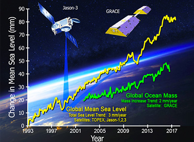
JPL researchers are involved in several altimetry missions (Jason, OSTST) that measure present day sea levels. Other missions such as GRACE, IceSat-1/2, and IceBridge (in which JPL researchers are also involved) quantify present-day contribution of polar ice sheets, glaciers, and ocean circulation to sea level, and help improve our understanding of processes that constrain projections of future sea-level rise.
-
What are the processes forcing the regional distribution of sea level change and water mass contributions from land hydrology and melting ice?
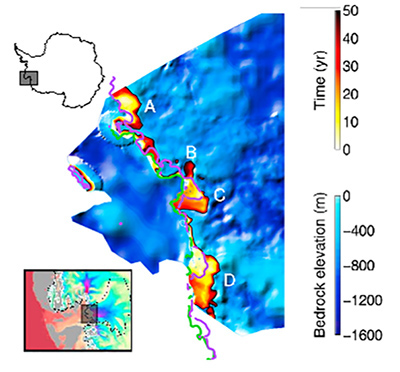
Several missions such as GRACE, IceBridge, and OMG, along with altimetry missions on the oceans, are involved in this challenge. Researchers rely on ECCO and ISSM to assimilate this observational data into a better understanding and calibration processes and to represent such processes in projections of future sea-level rise.
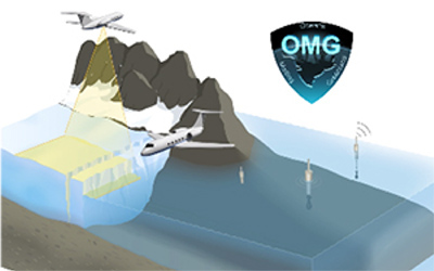
Oceans Melting Greenland (OMG) is using airborne radar and air-launched ocean probes to investigate how the oceans are interacting with glaciers in Greenland to contribute to Greenland's ice loss.
How do the ocean and ice sheets interact to drive sea level change?
Coupling two frameworks, ISSM and ECCO, allow JPL researchers to understand the impact of ocean circulation on melting rates underlying ice-shelf cavities. They rely on data from OMG and OIB to constrain such coupling, in particular in fjords around Greenland. OMG is also directly used to observe processes linking ocean fjord circulation with dynamic thinning of Greenland glaciers.