Solid earth research focuses on researching processes that occur within Earth’s crust, mantle, and core. These include the following problems:
- Understanding the underlying physics that control hazardous events such as earthquakes, volcanic eruptions, and landslides
- Understanding the role of land elevation changes in monitoring sea level change, ranging from mantle processes (glacial isostatic adjustment) to local phenomena (groundwater extraction; sediment compaction)
- Advancing remote sensing methods to observe changes in the Earth's surface and interior using radar, GNSS (Global Navigation Satellite System), hyperspectral imaging, gravity, and optical data
- Developing next generation observational and modeling techniques to study the Earth’s crust, mantle and core
The Earth Surface and Interior focus area of NASA’s Science Mission Directorate primarily provides support for this research. NASA’s Challenges and Opportunities for Research in Earth Surface and Interior report (CORE Report, 2015) details the current scientific and technical challenges that are being addressed in this area.
Current Challenges
Solid earth research at the Jet Propulsion Laboratory is geared towards addressing the following challenges, and are described in greater detail below:
- What is the nature of deformation associated with plate boundaries and what are the implications for earthquakes, tsunamis, and other related natural hazards?
- How do tectonic processes and climate variability interact to shape Earth’s surface and create natural hazards?
- How does the solid Earth respond to climate-driven exchange of water among Earth systems and what are the implications for sea-level change?
- How do magmatic systems evolve, under what conditions do volcanoes erupt, and how do eruptions and volcano hazards develop?
Researchers at JPL use data from multiple NASA missions, including Terra (carrying the ASTER, MODIS, and MISR instruments), Aqua (AIRS, MODIS), Aura (OMI), SNPP (OMPS, VIIRS), GRACE, and GRACE-FO. They are also part of the Solid Earth Science Team for NASA’s first InSAR mission (NISAR), planned to launch in 2022, and are contributing to the SDC designated observables. Many also contribute to the Science Study Teams for HyspIRI and SBG. In addition to these NASA space missions, researchers use GNSS data, airborne data (UAVSAR, GLISTIN, MASTER, AVIRIS, HyTES), and UAVs to constrain models of tectonic, volcanic, and hydrologic processes. These researchers have made extensive use of radar data from international missions, such as Envisat, ALOS-2, COSMO-SkyMed, TerraSAR-X, and Sentinel 1 to address solid earth processes.
Deformation on plate boundaries implications for earthquakes and tsunamis
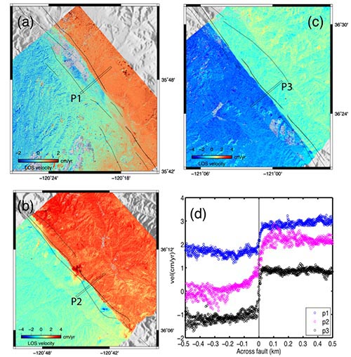
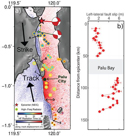
Interferometric synthetic aperture radar (InSAR) from both airborne (the NASA UAVSAR) and satellite SAR systems allows for broad (up to 100s of km) and fine (<10 m) sampling of surface deformation. This provides detailed imaging of surface deformation velocities along creeping faults, such as the central San Andreas Fault in California to complex surface deformation associated with a large earthquake in Indonesia that also created a damaging tsunami.
Tectonic Processes and Climate Variability shape Earth’s surface and create natural hazards
Research on natural hazards includes studies of landslides. Primary methods are SAR interferometry and pixel correlation using existing satellites and the airborne NASA UAVSAR radar. Variations in precipitation have a strong effect on landslide motion and can lead to catastrophic collapse.
Solid Earth response to climate-driven exchange of water among Earth systems and the implications for sea-level change
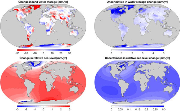
On-land changes in ice and water mass induce perturbations in Earth’s gravitational and rotational potential. The direct loading/unloading of ice/water mass and the perturbed potentials together deform both the geoid height and the underlying solid earth. These processes together yield a particular spatial pattern of ocean mass distribution, commonly known as the sea-level fingerprint. The sea-level fingerprint is usually characterized, for example, as changes in relative sea level encircling areas of intense ice mass loss such as Patagonia, coastal Alaska, the Amundsen Sea sector of West Antarctica, and the Greenland Ice Sheet.
Magmatic system evolution and eruption processes
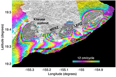
Volcanoes represent complex coupling of magmatic movement through the solid earth. As magma rises through the crust it releases gases and as it accumulates pressure builds, often being released in dynamic eruptions that are manifest by complex surface deformation and release of gases.