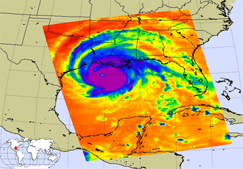
In spite of recent improvements in the forecast accuracy for hurricane tracks, atmospheric scientists still have many unanswered questions about the physical processes that determine the formation, intensity, track and large-scale atmospheric impact of hurricanes. Improving the understanding and forecasting of these factors – particularly sudden intensification and weakening – remains a challenge for the operational and research communities. A significant amount of work remains to be done in validating hurricane forecast models, understanding their sensitivities and improving their parameterizations. None of this work can be accomplished without a comprehensive set of multi-parameter observations that are relevant to both the large-scale and storm-scale processes in the atmosphere and the ocean.
To address this need, researchers from the Jet Propulsion Laboratory have developed the framework for the Tropical Cyclone Information System, or TCIS.
The development team’s goal for TCIS was to create an online one-stop shop for researchers, with an extensive set of observed hurricane data and their graphical representations, together with convection-resolving model output. The system is organized to make it easy to determine when coincident observations from multiple instruments are available.

The Web interface combines high-resolution satellite and in-situ observations, and will soon include model outputs pertaining to the thermodynamic and microphysical structure of storms, air-sea interaction processes and the larger-scale environment. For convenience, all storm-scale observations are presented in a common space, centered on the storm.
“The year 2005, for example, had a very active hurricane season, and the following year was expected to be similarly intense,” said JPL atmospheric scientist Svetla Hristova-Veleva, one of the researchers leading the development of TCIS. “However, 2006 was comparatively quiet. By making it easier to contrast the various data sets from the two adjacent years, we may enable scientists to understand what environmental conditions are responsible for determining hurricane frequency and intensity,” she said.
The resources available from TCIS can support both research and field campaigns. Users employ the system’s Web-based analysis tools to mine an expanding database, allowing for online investigations without the need to download large data volumes. The intent is to provide analysis tools that can be used to compute single and multi-parameter statistics and to determine spatial, temporal and multi-parameter covariances that are needed to evaluate model performance, provide information for data assimilation and characterize and compare observations from different platforms.
Currently the TCIS contains satellite observations of all tropical cyclones observed globally during 2005. The group plans to extend the database to include storm data from 1998 to present.
In addition, the JPL team is joining efforts with researchers from NASA’s Marshall Space Flight Center to create the Tropical Cyclone – Data Exchange and Analysis System (TC- IDEAS) as part of the NASA Hurricane Science Research Program. In addition to the satellite, in-situ and model data and analysis tools that are part of the current TCIS, TC-IDEAS will also incorporate NASA field campaign airborne and in-situ data and display them using a Google Earth field-campaign-specific approach that allows the creation of overlays on-demand. This innovative approach, known as the Real Time Mission Monitor (RTMM), was developed at Marshall and has proven very valuable in the past, both during field campaigns and in post-campaign analysis.
As the TC-IDEAS database expands, its developers intend to incorporate new analysis tools with inputs from the broader atmospheric research community. Within a couple of years, a fully functional TC-IDEAS, and its JPL TCIS component could help support both research and field campaigns; improve the understanding of hurricane processes; improve hurricane forecasts by facilitating model validation and data assimilation; and enable the development of new algorithms, sensors and missions.
The informal JPL team includes more than 35 scientists who meet bi-weekly to discuss hurricane-related scientific issues and to share ideas on the TCIS design. The TCIS was developed by a dedicated team of three JPL Information Technology experts (Brian Knosp, Peggy Li and Quoc Vu) and under the guidance of a steering committee of 18 (Svetla Hristova-Veleva, Yi Chao, Bjorn Lambrigtsen, Ziad Haddad, Deborah Vane, Joseph Turk, Hui Su, Brian Kahn, Evan Fishbein, Simone Tanelli, William Poulsen, Stephen Durden, Anthony Mannucci, Alexander Ruzmaikin, Philip Callahan, Michael Garay, Van Dang, Chi Ao).
Links
- Tropical Cyclone Information System: http://tropicalcyclone.jpl.nasa.gov
- The Real Time Mission Monitor: http://rtmm.nsstc.nasa.gov
- Science Data Processing, Analysis, and Visualization at JPL: http://tr.im/kxoN
Reference
-
S. Hristova-Veleva, Y. Chao, Z. Haddad, B. Knosp, B. Lambrigtsen, P. P. Li, D. Vane, Q. A. Vu. (2009) "An Integrated Tropical Cyclone Information System for Research." 63rd Interdepartmental Hurricane Conference. March 2009, St. Petersburg, FL.