A lidar technique being developed by the Jet Propulsion Laboratory may have a promising future for monitoring changes in the concentration of water vapor, which is a powerful greenhouse gas, in the poorly understood region of our atmosphere between the troposphere and the stratosphere.
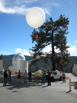
The Measurements of Humidity in the Atmosphere and Validation Experiments, or MOHAVE, campaign recently wrapped up its third season of observations at JPL’s Table Mountain Facility, located near Wrightwood, Calif., in the Angeles National Forest northeast of Los Angeles. The campaign uses JPL's water vapor Raman lidar, along with three visiting lidars from NASA's Goddard Space Flight Center, to validate atmospheric water vapor measurements with the ultimate goal of determining long-term water vapor trends in the upper troposphere and lower stratosphere.
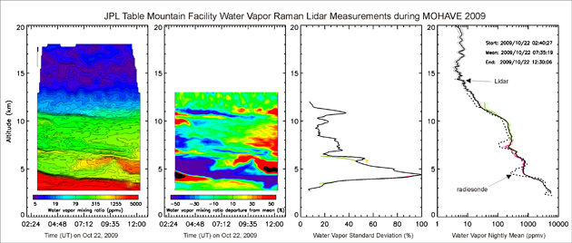
MOHAVE provides continuous water vapor profiles from the ground to the mesosphere by combining measurements from more than a dozen participating instruments and techniques besides lidar. The toolbox includes ground-based global positioning system instruments, microwave remote sensing, and in-situ hygrometer sonde measurements onboard balloons. These other techniques are used to characterize the accuracy of the lidar measurements of water vapor in the upper troposphere and lower stratosphere. The JPL water vapor Raman lidar is one of just a handful of lidars in the world that can make good water measurements at these altitudes.
Unlike a radar, which bounces radio waves off targets, lidars (LIght Detection And Ranging) instead bounce short pulses of visible, ultraviolet or infrared light. A laser beam is sent into the atmosphere, and some of its light gets reflected off molecules and particles in the atmosphere and is “backscattered” back to the ground. Depending on the wavelength of the emitted light, the type of scattering objects (molecules or particles), and the type of scattering process, the light collected on the ground can be analyzed to learn more about the properties of the atmosphere, including the location, distribution and nature of molecules and particles in it.
The cloudless nighttime skies at JPL’s Table Mountain Facility make it one of the best places in the United States to collect atmospheric remote sensing data. In addition to the water vapor Raman lidar, two other lidar systems at Table Mountain are used to measure atmospheric ozone, temperature and aerosol profiles. Specifically, a water vapor Raman lidar measures vertical profiles of the ratio of water vapor to dry air. Its use at the Table Mountain Facility allows researchers to monitor changes in the amount of upper tropospheric water vapor related to the activity of the subtropical jet stream, which flows over Southern California.
The subtropical jet stream burrows through the tropopause (the boundary between the troposphere and stratosphere), creating a region where species such as water vapor can be transported both vertically and horizontally. This interface between the worlds of the troposphere and stratosphere, and between the midlatitudes and the subtropics, is not yet well understood. A key objective of the MOHAVE campaign will be to study the mixing of material between these atmospheric reservoirs.
The lidar technique also has a major advantage compared to ground-based or satellite radiometers: the time at which the laser pulse leaves and comes back to the ground is known very precisely (usually to the nanosecond). Because it has a time reference, lidar, which is an active remote sensing technique, can very precisely determine vertical resolution to within a few meters. (Passive remote sensing techniques such as radiometers collect a continuous flow of light without knowing precisely where it originates from.) Accordingly, another objective of this year’s MOHAVE campaign was to help validate the Tropospheric Emission Spectrometer and Microwave Limb Sounder instruments on NASA’s Aura satellite, which passed through the skies above Table Mountain several times during the campaign.
High and Dry
Thierry Leblanc, who leads the MOHAVE project, explains that most of the water vapor lidars in the world are dedicated to studying the lower troposphere – altitudes between the ground and about 10 kilometers (6 miles) – and good measurements of humidity already exist for this region. As altitude increases, however, it becomes increasingly difficult for lidars to get a good signal. In addition, the air in the upper troposphere is extremely cold and dry – the ratio of water vapor in the atmosphere decreases from 40,000 to 50,000 parts per million on the ground to just 5 parts per million at altitudes of 12 kilometers (7 miles) and above. This scarcity and cold temperatures make it quite challenging for any technique to measure water vapor at such heights.
Even though it is rarified in the upper troposphere, water vapor is an important greenhouse gas. Only carbon dioxide is more potent. Because water vapor is extremely variable in the lower troposphere, higher altitudes provide a better vantage point to look for its long-term variability. “From a climate change point of view, it's actually more important for us to detect possible trends in the upper troposphere and lower stratosphere, between 10 and 20 kilometers (6 to 12 miles), because there are so few techniques that can do this," Leblanc says.
Trendspotting
Because researchers have not previously been able to capture every detail of how atmospheric water vapor content varies above the lower troposphere, it has been difficult to understand possible trends. In the mid-latitude stratosphere, there was a general increasing trend prior to the year 2000, followed by a sudden drop. It now appears that water vapor in the region is again increasing, but Leblanc says the community needs more data to determine whether this is part of a natural variability associated with long-term climate cycles. The oxidation of methane is a source of water vapor in the atmosphere, and increasing amounts of methane are estimated to account for about a third of the trends observed before the year 2000.
Build a better lidar
Water vapor lidars are still considered experimental for this type of study. “We can compare what we are doing now to what lidar researchers were doing with ozone 25 years ago,” Leblanc says. Since that time, lidar observations have become increasingly reliable for monitoring ozone and identifying trends in its distribution.
The JPL lidar instrumentation has evolved with time, and the MOHAVE team is continuously working to improve their receivers and other components. As in the two previous MOHAVE campaigns, in 2006 and 2007, nearly all the participating instruments were directly linked to the lidar measurements. This is because a water vapor Raman lidar requires calibration from an external measurement of the gas. This could be just one point in a balloon measurement, for example, or it could be the total water vapor content in a column of air measured from the ground.
By characterizing the error in each total water vapor measurement and comparing measurements from the different instruments over the course of the campaign, the team gets a better idea about the real accuracy of each technique. “So if we find that one, or several, of these techniques provide accurate calibration, then we’ll know that in the future we can use them systematically,” Leblanc says.
The MOHAVE team is currently sifting through the data from their intense two-week observing run. “We are catching up on missed sleep. We have a wealth of measurements to analyze, and it will take months,” Leblanc says. “The team plans to organize a workshop in early spring to share results. And then we’ll see what the future holds.”
Links
- MOHAVE Project page
- JPL’s Table Mountain Lidar Group’s website
- JPL’s Table Mountain Facility
- Aura Mission Website
Publications
- Leblanc, T., et al. (2011), Measurements of Humidity in the Atmosphere and Validation Experiments (MOHAVE)-2009: overview of campaign operations and results, Atmos. Meas. Tech., 4(12), 2579-2605.
- Leblanc, T., I. S. McDermid, and T. D. Walsh (2012), Ground-based water vapor Raman lidar measurements up to the upper troposphere and lower stratosphere for long-term monitoring, Atmos. Meas. Tech., 5(1), 17-36.